Wednesday, 31 October 2012

A different kind of desert

After reaching the end of Route 66 yesterday, we bolted back east.  Greater L.A. sprawls about 80 miles north, south and east of downtown.
It took about 3 hours in rush-hour traffic to escape the suburban sprawl of southern California, up and over the mountains to the Mojave desert.

We spent the night in Yucca, close to the north entrance of Joshua Tree National Park.  We visited the park in the morning.


Whereas the Sonoran desert is lower, warmer, wetter, and has its iconic saguaro cactus, the Mojave is higher, cooler, drier and has lots of yucca plants.  The most famous yucca is the Joshua Tree, found where the Mojave and the Sonoran meet.


A field of Joshua Trees in the distance.
The Joshua tree reaches about 20 feet in height.


The park is also home to many rounded rock formations.  These are a type of granite that fractures into blocks, and then weathers into rounded corners by groundwater.  When the overlying rock is eroded, the rounded rocks are exposed.

The vertical cracks in these rocks make them very popular with rock climbers.

The San Andreas fault is visible as it runs through the valley here.

Bee careful.  We are close enough to Mexico that so-called "killer bees" are a problem.

The view from Keys Point:  Palm Desert is barely visible at the base of the mountain in the distance. 

The Salton Sea is barely visible in the distance. It is not mist; it is smog.  The winds coming in off the Pacific ocean exit through these valleys, carrying the pollution of the millions living in southern California with them.  The air quality today was "moderate".

Cap Rock looks like it is about to fall down.  Geologically speaking, that is true.

Look closely, and you will see a couple of rock climbers sunning themselves on the top of Hidden Horrors.

The aptly-named Skull Rock.

A large cluster of cholla cacti.  These are 2 to 3 feet tall.

The drive through the park was about 60 miles. After exiting the park on the south side, we drove through the vast agricultural belt that extends south and east of here, where citrus, dates and grapes are grown using irrigation water from the [once-mighty] Colorado river.  We didn't stop to take a lot of photos, and headed for Yuma to stay the night.


Elfrida slowed way down to check this place out.  I am wondering if they are a subsidiary of Pfizer Corp.


The End of the Road

Today, we made the last segment of Route 66, from San Bernardino, which is about 80 miles inland, to Santa Monica on the cost.   In the 1930's this was mostly farmland, with roads laid out in straight lines wherever geography permitted.  But now it is prime Southern California real estate, and is one continuous suburb.  It took about 4 hours to drive the last 80 miles.  You have to pay attention to signs to figure out when you have passed from one town into another.


Yes Virginia, there really is a Rancho Cucamunga.

The 60's were a wonderfully simple time for branding...
 There were lots of vintage signage along the way:


A view downhill along Foothills drive.  Note the smog!

The palms are all curved towards the south.

Route 66 manages to pass a fair number of cultural icons in its last few miles:
Views of the famous Hollywood sign appears from time to time

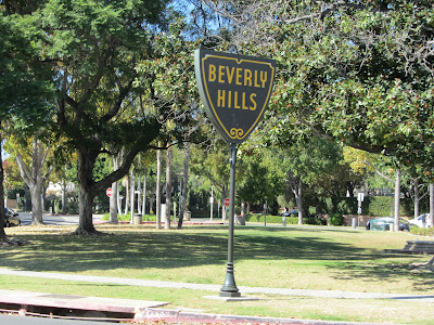
It goes through Beverly Hills.


It crosses Rodeo Drive.

The "official" end of Route 66 is the rather unsatisfying intersection of Lincoln Avenue at Olympic.  But popular consensus extends it about a mile and a half to Ocean Drive and the cliffside Palisades Park.

No marker here. Just several closed business properties awaiting redevelopment.

Elfrida at Lincoln & Olympic.

Another "official" end of the highway, in the grass of Palisades park, which unfortunately has become popular with the homeless. 

And a few feet away, another more photogenic official end marker, addressing the needs of the camera-laden.

The Santa Monica Pier is a nearby.


Monday, 29 October 2012

"It's just you, me, and America"

This is what Elfrida said to me today, as we crossed the Mojave Desert, travelling from Needles to San Bernardino, California.  We encountered practically no other travellers, and we never left San Bernardino County, which is the largest in California with some 20,000 square miles.
A view south across the Mojave desert.  Notice the horizontal striations visible in the distance.  This is natural, not man-made.  I'll ask a geologist why.

The road is bordered to the north by a berm that buries a fiber optic cable.  People collect colored stones to spell out names, political humour, etc. on the berm.  I'm not a fan of graffitti or other "public art" but this seems pretty harmless.

The Road Runner Restaurant, rusting and resting in ruins.

More public art.  This is the Shoe Tree.  It is the only tree taller than 6 feet for miles around, and unluckily close to the road.

Amboy Crater, a volcano that last erupted about 10,000 years ago.  A freight train is in the foreground.

A Route 66 classic, lovingly restored by a local millionaire.  The gas station/cafe is operational; the motel is mainly a movie set for now.

It's not a trick of perspective - the roof really is angled.  Very 60's.

Amboy Crater.  Its about 1500 feet in diameter.  The hike from here to the crater and back is 3 hours. 

Something lives here; these holes are about 4 inches wide.

Lots of bug guts on the bumper.  I've been scraping the windshield at every fillup.  It may be a desert but it's certainly not lifeless.

Iconic cafe appearing in many Hollywood classics.

Unusual roof.

Giant Alert: The parrot on this sign is about 12 feet tall.  The gasoline price is 1950's. 

Pretty mountains in background; more berm art in foreground.  This is not my best composition but when I moved to get a better shot, I heard a rattlesnake rattle and backed away.
Just north of the road.  We found out about this place from the Billy Connolly series.

Local artist and eccentric Elmer Long welds branches to steel pipes, sets them in concrete, and decorates them with bottles.  A friend stuck a broken mining pick in the top of one, so Elmer now puts something special atop each one.

Elfrida with Elmer Long.  Cheerful, talkative guy, he came out of his house to talk with us.

"Bring us a shrubbery!"  (This will only make sense to Monty Python fans.)

After this, we came down the Cajon Pass into San Bernadino, exiting the desert and entering the suburban edge of the vast greater Los Angeles area. 

Sunday, 28 October 2012

Route 66 Part 2 - Tucson - Flagstaff - Needles

Elfrida restocking the hummingbird feeder.
Last October, we drove the Ford down to Tucson, we being my sister Elfrida, her husband Terry, and myself.  We started in Chicago and drove Route 66 all the way to Flagstaff, Arizona, where we broke off to drive down to Tucson.

Well, Elfrida is back in Tucson (without Terry this particular time) and the plan is to drive the rest of Route 66 from Flagstaff to Santa Monica, CA.  


A nice sunrise over the Catalinas in Oro Valley before heading out on Saturday.


Picking up where we left off, in downtown Flagstaff, at the intersection of Beaver Street and Route 66.  It is 26F out, on its way up to 68F.

An interesting general store in Parks, in pine country.  At 7000 feet, the weather is sunny but cool.
The store is heated by a potbelly stove in the center of the building.  Elfrida wonders how many customers have accidentally backed into it while shopping.

The restaurants along '66 in Williams need to compete for your attention.  The name of this one caught mine.  They offer "home cooking."  Really?

The Snow Cap is an institution in Seligman, AZ.  The guy behind the counter is a practical joker.  For example, the door has knobs on both left and right side.  Only one is real.  The other has you ineffectually trying to pull open the door from the hinged side.  If you order a chicken sandwich, you are likely to get a rubber chicken between two slabs of bread.  The group in front of us ordered 3 medium Cokes and one small; he served the small in a 1-ounce condiment cup.  It took a good minute of animated discussion in German before they decided to return to the counter and complain.
 Once you leave Selgman, you have about 150 uninterrupted miles of original Route 66 without I-40 anywhere in sight.

Yet another Route 66 attraction, this one in Hackberry, AZ.  Recipe for Route 66 roadside attraction: 1. Buy a rundown building (previously used for any purpose) on the highway.  2. Gather as much 1950's and 1960's Americana as necessary to decorate every square foot of the exterior facing the road.  (The classic '61 Corvette convertible sure helps!)  3. Stock it with giftware.  Best choice is millenial humour using 1950's images.

This Easter Island tiki is about 3500 miles off course.

A nice old steam train in Kingman, AZ.

This stone gas station in Cool Springs had fallen to rubble years ago.  The ruin was bought for a song by a movie director, who had it reconstructed so that it could be cinematically destroyed again by Claude Van Damme in the movie "Universal Soldier".  A local entrepreneur then bought the re-rubbled property for a song and reconstituted it yet again, with added celebrity as a former movie set.

Elfrida and the Ford, near the top of Sitgreaves Pass.

The road down to Oatman has a lot of hairpin turns.  Guardrails range from nominal to non-existent.

Oatman is known for its wild burros that wander at will around town, oblivious to traffic, trying to cadge food from visitors.  Now I know what cities and towns smelled like before the automobile came along.

Mother and child.  Is the young burro a burrito?

Looking back to the east to the hills as the sun sets (and a full moon rises.)  We are now in California, approaching Needles.